Special focus on the history of South Mountain, Catoctin Mountain and the surrounding communities during the Civil War, including the War of 1812 and the French & Indian War.
Recently, on Penn Pilot, a website of aerial photographs of Pennsylvania, I am able to help explain visually what Monterey Pass looked like at least during the 1930’s as Route 16 or Sunshine Trail was being cut in. The roads that were used during the Civil War are still visible and still in use as this new highway was being cut in.
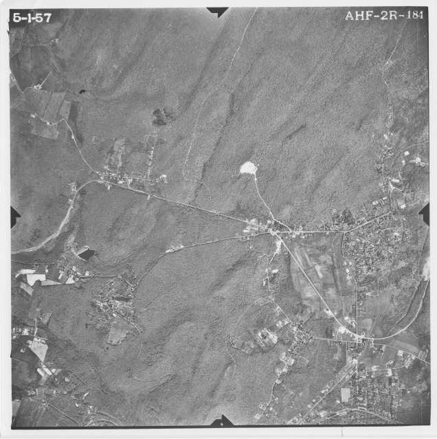
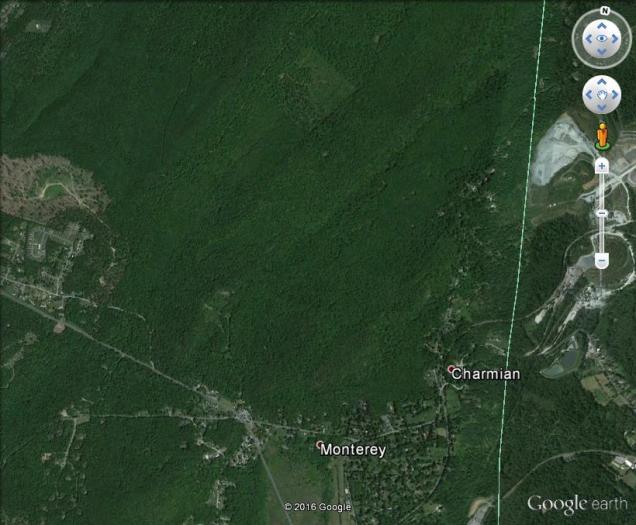
This map is a early 1900’s map of Monterey Pass. The map shows the layout of all of the roads in the area. Here is a 1937 aerial view of the Monterey Pass. You can still see all of the roads and the construction of Route 16. See the next photograph for the labeled roads.This is a fairly good aerial view of Monterey Pass. You can still see all of the network of roads. The toll house is located on Waynesboro Road where Pennersville Road connects between the triangle. Here is a 1957 aerial view of Monterey Pass after Route 16 has been completed. A modern day view of Monterey Pass. Notice how many of the roads are no longer visible from the air. Where you see the word Monterey, this is where the golf course is located.
Each year, thousands of people travel to Gettysburg National Military Park. Many will see the film and the Gettysburg Cyclorama before venturing out onto the battlefield. When most people see the Gettysburg Cyclorama, I often wonder if they see the same heavily influenced French military culture that I see? Even the most hardcore Civil War buff, I feel, fails to see that influence. Unless you’re a hardcore living historian who has spent years researching Civil War uniforms and equipment, like I have, you may not see the uniforms and equipment being worn by Union soldiers as that of the Second French Empire.
So let’s start at the beginning, what is a cyclorama? It’s a large painting that is displayed in the round. It often features a foreground that blends in with the scenery of the painting. It was considered as an exhibit, meant for entertainment, where a panoramic view totally surrounds the viewer, giving them a 360 degree view as if he or she was standing in the center inside the painting. This type of artwork has its roots dating back to 1787 when Robert Barker, an Irish painter, wanted to display a painting that captured a moment in time, giving the viewer the feeling that he or she was actually there. Robert Baker created a panoramic scene that eventually became known as a cyclorama. The cyclorama would gain major popularity in the mid to late 19th Century.
The Gettysburg Cyclorama is an oil painting done on canvas, and stands forty-two feet tall and three hundred, and seventy-seven feet in circumference. The Gettysburg Cyclorama that you see on display is number two out of four that the French artist Paul D. Philippoteaux and his team of special artists completed. The Boston painting, commissioned by Charles Willoughby of Chicago, IL for a sum of $50,000 was completed in just over eleven months in 1884. It was first displayed in Boston in late December. It made its way to Gettysburg in 1913 for the 50th reunion of Civil War veterans. Today, it is one of the largest oil paintings on display in North America and is the only one of four that Paul Philippoteaux completed between the years 1883-1886.
The Gettysburg Cyclorama captures the moment of the High Water Mark of Pickett’s Charge, the last major battle that was fought at Gettysburg on July 3, 1863. The painting, as some visitors will say, is the closest to seeing the ground as it was in 1863. There are no monuments, no highway and no modern buildings. I’ve seen people tear up because of how the painting is displayed, and how they felt they were a part of it. I have also seen people who couldn’t care less about the painting because of what it portrays, war! Either way, the painting has stood the test of time.
How did the cyclorama craze begin here in America? In 1879, Paul Philippoteaux was commissioned to do the Chicago painting of Pickett’s Charge. In 1882, he arrived in the United States and conducted a great deal of research and interviews. He visited Gettysburg and hired a local photographer, William Tipton to take a series of photographs of the landscape. The artist took all of his research back to Europe and began working on the concept. The Chicago version of the Gettysburg Cyclorama painting was unveiled and opened to the public in 1883. By December of 1884, the Boston painting opened. There would be two others that came after the Boston version debuted, the New York and Philadelphia paintings. Over time, the Boston version would be the sole survivor.
Let’s take a closer look at the French Military influence that we see in the Gettysburg Cyclorama. Let’s begin with the artillery you see in the Gettysburg Cyclorama.
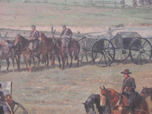
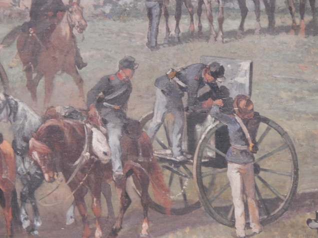
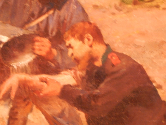
The First Rhode Island Artillery, Battery A (Arnold’s Battery) was equipped with 3-inch Ordinance Rifles and not Parrott rifles as seen in the painting. These men are also using some weird type of drill that looks similar to the reduced numbers drill.This Battery wagon (Battery A, 1st R. I.) should not be this close to the fighting. They were further back and ready to make repairs in the field as needed.I love how the lid on the limber chest opens the wrong way, towards the battery. They should open from behind with the top of the lid facing towards to the guns.Members of the 13th New York Artillery. Notice the kepi that are being worn instead of the Federal regulated forage cap. Also, notice the red should-straps, and red tape on the sleeves with three buttons. Some of the artillerymen have a solid red cuff on their sleeves rather than the tape you see in this photograph. These jackets are not of the Federal Government issue, but rather they are uniforms of the Second French Empire. I do like the mixture of slouch hats that the artist places into the painting.Here is a better photograph of a NCO wearing the French tunic. He is also wearing some type of cartridge box suspended by a buff leather strap. The buff belt holds a LeMat revolver inside of a brown leather holster.Notice the red shoulder-strap and blue collar. This is what I would call a blooper.The New York State Militia Guidon. This is to represent the 13th New York Artillery coming to the front. This guidon is incorrect. The 13th New York Artillery was never part of the New York State Militia. In fact, in 1862, the New York State Militia was changed to the New York State National Guard.Again, notice the red tape located at the cuff and the white haversack on the guy located left. The white haversack is part of the French military issue to its army. Now look at the guy on the right who is wounded. Notice there is a lack of a cuff, but retains his red collar and shoulder-strap.I love the detail of this Union artillery officer. Notice his shoulder-strap signifying he has rank. He still retains the red collar for his branch of service, the artillery. The Union army used shoulder boards for the most part to signify rank. Also, notice the French style kepi which actually would be correct for an officer in the Union army if he choose to wear one.This is General Henry Hunt, Chief of Artillery. For the most part, he looks good. He has shoulder boards, red sash and saber belt. He even wears a kepi. But notice the French braid on his sleeves. The Union army officers very seldom had these on their jackets. Also, notice the collar. It appears to have some sort of insignia that could be used for his rank or branch of service.Notice the cartridge box marked with U.S. Also, this is a good closeup of the equipment used for the horses.This guy appears to be some sort of officer, judging by the red shoulder board. What I life about this guy, is you can see what the French uniform looked liked from the back of the soldier. Again, the cartridge box and saber belt are standard French issue accouterments.
Let’s take a look at the infantry.
The Byrd Brothers. You can see the left brother is wearing a tunic that appears to be an eight button from. You can make out the blue collar and should-straps. The brother on the right, is wearing an officers jacket. You can see the French braid as well as some sort of shoulder board and blue collar.I like this picture because of the soldier on the left. He is very large compare to the normal size soldier.This is a great view of the hard pack knapsack and how the blanket was attached. You can also see the mess kits, cartridge box, scabbard and yes, the haversack. All standard French issue.Various blanket rolls and accouterments.This is a good close up of the infantry tunic. Notice the collar, shoulder straps and cuffs. The eight button front along with French blue trousers and white shirt. You can also see a close up of the canteen, cap pouch and belt with buckle.Another close up of the cap pouch and haversack and the tunic.Close up of the top of the tunic.The knapsack, blanket and mess tin.
Odds and ends.
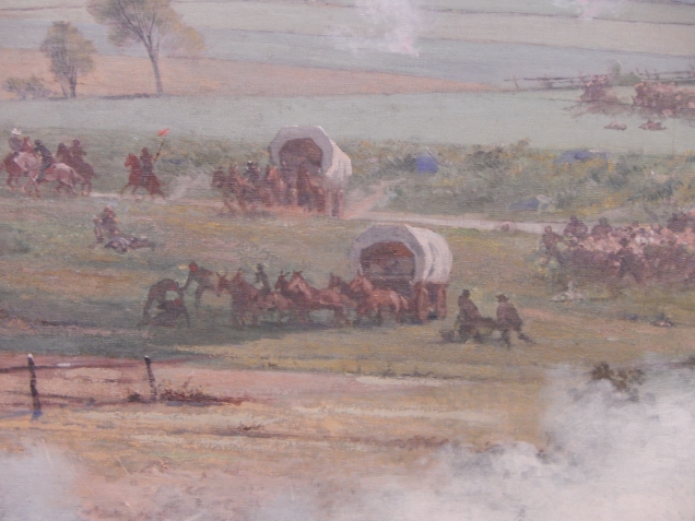
The usage of pack horses.The usage of horses and hospital saddles to remove wounded men. This also shows the usage of African Americans as contractors in the military.The usage of wagons moving with Pickett’s men during the charge. Wagons were parked well west and north, northeast of the battlefield. Read the Retreat from Gettysburg related articles that I have online.
Monterey Pass is full of history. Many will associate this mountain gap for the name given to a major Civil War battle that was fought during the night of July 4-5, 1863. While it’s true that the Civil War was a major historical event, it wasn’t the only historical event to take place in this area. Years after the battle, this area was home to hundreds of inner city bureaucrats which led to the Resort era.
Mining and the railroad were part of the huge industrial revolution that led to the area’s wealth, but declined during the Great Depression. Soldiers would again visit the area during World War Two, as a military camp was established by the U.S. Army at Camp Ritchie. But with all of this, there is a forgotten era that relates to Monterey Pass. That era begins just a few years before the French and Indian War.
Monterey Pass and Fairfield Gap were known by many names in Colonial America. On period maps, the Monterey Pass area was known as the South Gap, Nichols’ Gap, Nicholson’s Gap, and by the 1770’s as Willoughby Gap. It wasn’t until toward the early 1800’s that the name changed to Monterey Pass. Fairfield Gap was most likely given the name after the founding of that town.1
Monterey Pass is situated on South Mountain. South Mountain is a mountain range that is associated with the Blue Ridge Mountains, although the extension of the Blue Ridge Mountain ends at Boonsboro, Maryland and it known today as Elk Ridge. The mountain itself spans seventy-one miles begging near Hillsboro, Virginia known as Short Hill Mountain. From there, Short Hill rises to the south side of the Potomac River. On the north side of the Potomac River, it rises in Maryland, continues into Pennsylvania, and ends near the Susquehanna River between Carlisle and Dillsburg. This portion of the mountain is called South Mountain.2
During colonial period, anything west of the mountain ridge was one vast wilderness with the exception of some forts and stockades to protect settlers and some small settlements. The mountain is full of natural resources. Hemlocks, maple, beech, basswood, chestnut oak, northern red oak, northern pine, birch, and poplar were the basic types of trees that grew in the forest.3
Aside from trees, South Mountain had an abundance of wildlife and fish to sustain life on the frontier. Crystal clear springs and creeks such as Toms Creek and Antietam Creek were given life from the mountain.
West of South Mountain is the Cumberland Valley. Then, it was known as the Great Valley. The area was open for immigration for settlements after treaty cessions and purchases from the Indians in 1764, ending the French and Indian War. Prior to then, two main roads were created to allow settlers to flow into the valley.4
In 1744, a treaty between the English colonists and the Indians gave the white men control of the road for the first time. By 1765 the Great Wagon Road was cleared all along it way enough to hold horse drawn vehicles and by 1775, the road stretched 700 miles.
With immigrants flooding the new world, land was becoming scare. As a result, in the mid 1740’s, the Scots-Irish began looking for newer and less costly means of land to farm upon. By the mid 1700’s, Pennsylvania Germans would also migrate. West of South Mountain and areas to the south in what we call Appalachia was rich with fertile farmland, but it was also a rough place to live.
In February 1747, people petitioned the Lancaster county government for a road to be laid out ‘from the Conocheague through the gap in the mountains of Lancaster.’ Known as the Black’s Gap Road. A second road was surveyed that linked the headwaters of the Antietam Creek with York and Lancaster and became known as the Nichols’ Gap Road. This road branched off the Black’s Gap Road near New Oxford. It paralleled Route 116 from Gettysburg to Monterey Pass.5
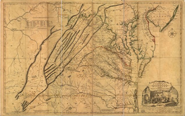
The Jefferson and Fry Map, 1755, LOC.
This road began in Philadelphia and would encompass the modern day towns of Lancaster, York, Harrisburg, Dillsburg, Gettysburg, Fairfield, Monterey Pass, Hagerstown, and Williamsport before entering into West Virginia then Virginia. Other forks of the Great Wagon Road would also link at Williamsport, MD. At Harrisburg, a road led to Carlisle, Shippensburg to Chambersburg and to Williamsport. From there, these roads converged and would lead travelers to North Carolina. Later the wagon road was extended to South Carolina and Georgia. Today, we call this area Appalachia.
The road itself was not very wide. The first settlers more or less walked along side of pack horses that contained all the family’s valuable items. In some places, the path was only three to four feet wide. Later, oxen would pull two wheeled carts loaded with supplies. Over time, as thousands moved upon the road, it became wide enough for wagons to transverse through. The Pennsylvania- Germans built wagons (Conestogas) at their largest would be twenty-six feet long, eleven feet high and some could bear loads up to ten tons. It took five or six pairs of horses to pull them.
W. Scull, 1770. Hamiltonban Township, Adams County, PA.
The fastest loaded wagon could go about five miles a day. The trip took a minimum of two months. Wagons broke down, rivers flooded, supplies gave out, and there was sickness but no doctors. Wagons were repaired, floods ceded, the wilderness supplied, and the sick were buried or stumbled on.6
The Great Wagon Road in our area featured many taverns. The sounds of hooves, wagon wheels, chains and supplies jolting along this road were common sounds. At night, many immigrants headed to Appalachia bedded down waiting for dawn to keep moving to a new life that awaited them.
In 1787, this great road became and official Pennsylvania highway and was improved upon. Work parties were sent out to make repairs when the road was damaged and kept traffic flowing.
Notes:
Looking at various period maps, one can easily trace the renaming of our mountain pass. The 1755 Jefferson-Fry Map, you can study the road that came through our area.
South Mountain is associated as being part of the Blue Ridge Mountains, but people often get that confused with the actual Blue Ridge Mountain itself.
Pennsylvania DCNR has a trail system along Route 16 near Rouzerville and Monterey Pass Battlefield that is called the Bicentennial Trail. It features markers that tell about the trees and their uses during the 1700’s. This trail explains what types of trees there were present on South Mountain during this period.
There were upwards to a population of about 3,000 in the Cumberland Valley prior to the French and Indian War. Many of these settlers were illegally living on Indian lands. During the F&I War, the population dropped to 300 as Indian raids occurred and were often bloody.