Rediscovering Colonial America: Forbes’ Campaign for Fort Duquesne, Part Four

During the month of October at Loyalhanna, Colonel James Burd, the garrison commander continued training and organizing troops for the final push toward Fort Duquesne. Colonel Burd also organized the horses, livestock and wagons, along with stockpiles of supplies. Several work details were sent out to improve or clear roads. During the month, heavy rains plagued the area, causing the roadways to deteriorate.

Higher up the British military chain of command, Brigadier General John Forbes tried to keep his Indian allies content and happy, which was a hard task to accomplish. Also, several colonies and British representatives began peace talks with thirteen chiefs of several tribes in the Ohio Country, including the Iroquois, Delaware and Shawnee. These talks were to help ease tensions over the 1737 Walking Purchase.

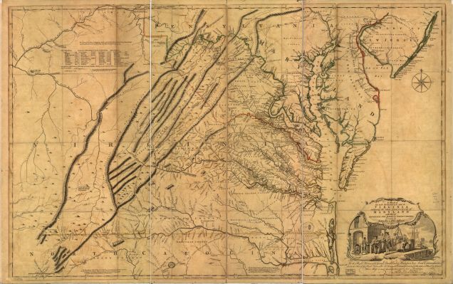
The Treaty of Easton prohibited the Indians from fighting on the side of the French during the French and Indian War. In return, it returned large portions of hunting land to the tribes in the Ohio Valley. The Treaty of Easton also redefined the colonial settlements west of the Allegheny Mountain after the war. The treaty was signed in late October and would have a huge impact on the French at Fort Duquesne.

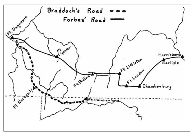
On October 16, Colonel George Washington and his Virginian militia arrived at Loyalhanna from Fort Cumberland. These men were welcomed reinforcements. While the troops worked, more supplies arrived, however other supplies, such as clothing and blankets, were in short supply. Colonel Henry Bouquet reported that many of his men needed clothing and equipment before moving out of Loyalhanna to siege Fort Duquesne.  Since the battle of Fort Ligonier, most of the horses were taken or killed. This forced the British army to wait for supplies to move in.

Brigadier General Forbes arrived at Fort Ligonier on November 2. He was not pleased with the conditions of the roads, weather and his men. These problems could force him to stall the campaign, and in fact, had already pushed the campaign’s conclusion back an additional month.

On November 11, Brig. Gen. Forbes held a council war with his top field officers and quartermaster. Brigadier General Forbes worried about the condition of his army and size of the French garrison he was assigned to attack. Brigadier General Forbes decided that the campaign could not go any further, as winter was about to set in. He made the decision to remain at Fort Ligonier for the winter.

A day later, a 40 Marine French detachment and 100-200 man Indian raiding party was spotted near Loyalhanna. Brigadier General John Forbes ordered Colonel Washington’s 1st Virginia Regiment and Lieutenant Colonel George Mercer’s 2nd Virginia Regiment out to meet the threat. As Lt. Col. Mercer was getting into position, Colonel Washington’s men were on the move in the fog. They heard movement, thinking it was the French and fired into Lt. Col. Mercer’s regiment.

During the exchange, Colonel Washington lost control of the skirmish due to weather conditions. The skirmish was a tactical defeat for the Virginians, resulting in two officers and thirty-eight men killed or wounded. A couple of French prisoners were taken. Brigadier General Forbes was outraged with Colonel Washington’s performance, which showed that the Virginians had much to learn with regard to discipline. Why, Brig. Gen. Forbes didn’t choose from the regulars that made part of the 4,000 men garrisoned at Loyalhanna for this task is not known.

Fort_Pitt.jpg
Plans for the future Fort Pitt.

On November 13, Brig. Gen. Forbes oversaw the interrogation of the prisoners, and conducted the interrogation personally. One of the prisoners was Richard Johnson, an Englishman captured a few years prior. During the interrogations, Brig. Gen. Forbes began gathering intelligence about Fort Duquesne. He quickly learned that the French were running low on food and manpower. Many of the Indians left due to the Treaty of Easton being signed, which Brig. Gen. Forbes had a huge role in. He also learned about the layout of the French fort. As he gathered information, he quickly countermanded his decision to stay at Loyalhanna for the winter.  If he was going to strike Fort Duquesne, this was the perfect time to do so.

His army was quickly reorganized, and would begin moving out on November 14, although some sources state it was the day after. The organization of Forbes’ army was broken and organized into four brigades. First Brigade was commanded by Colonel Bouquet, and consisted of the Pennsylvania Provincials and the Royal Americans. Second Brigade, commanded by Lieutenant Colonel Archibald Montgomery, consisted of the Highlanders and the 2nd Virginia Regiment. Brigadier General Forbes accompanied this brigade. Third Brigade was commanded by Colonel George Washington and consisted of the 1st Virginia Regiment, North Carolina Battalion, Lower Counties Battalion and the Royal Maryland Battalion. It also consisted of two companies of artificers and two field artillery trains.

The Fourth Brigade was under the command of the garrison commander, Colonel Burd, who remained behind. The garrison command consisted of several hundred men from various regiments and battalions. They were ordered to forward supplies needed for the march, and to provide protection for Forbes’ army if they came under attack by means of a fall back position. The men were ordered to march light and limit what they carried.

As the three main brigades moved out of Loyalhanna for the forty-seven mile trek to Fort Duquesne, they would maneuver by leap-frogging by brigade. Flankers would also be heavily used once past Chestnut Ridge. To avoid traffic congestion, each battalion within the brigade would march at various times of the day, staggering their movements.  Entrenchments were to be built at the end of the day at the various camp locations. Brigadier General Forbes wanted to make sure that the mistakes of Major General Braddock were not repeated.

At 8:00 a.m. on November 15, the first portions of the British army moved out of Loyalhanna.  One major natural barrier remained in Brig. Gen. Forbes way. This was Chestnut Ridge, the location of Grant’s Delight. Once past Chestnut Ridge, the valley floor, along with a few smaller ridges were what remained. Brigadier General Forbes would march along the ridge line of Chestnut Ridge, and then march down into the valley.

By November 19, Colonel Washington had marched to Turtle Creek while Lt. Colonel Montgomery was marching out of Loyalhanna. Brigadier General Forbes’ army stretched over thirty miles. On November 21, Colonel Washington was cutting in the road leading to Fort Duquesne. The next day, he held the advance at his camp until the main portions of British army began marching in.

On November 23, Brig. Gen. Forbes’ entire army was massed in Colonel Bouquet’s camp, located twelve miles from Fort Duquesne. It was here that Brig. Gen. Forbes changed his marching orders. Instead of marching the rest of the way by brigade, he ordered his army to march in column.

While the British were on the move, their movements did not go unseen by the French. The French commander at Fort Duquesne, Captain Ligonry, knew of the British advance and had several decisions to make.  The main decision was to stay and fight or evaluate the garrison. The French and Indian War was beginning to turn in favor of the British, as other campaigns were taking place, the garrison at Fort Duquesne was reduced to garrison other fortifications in the Ohio Country. Because of this, Fort Duquesne was being cut off from support.

On November 24, the British army begins it last movement to Fort Duquesne. By the time the French fort was in view, the British saw smoke rising from it. The French had set fire to the fort and left without a fight. But for Brig. Gen. Forbes, he would have to wait one more night before entering the charred remains of the fort.

At daybreak on November 25, Brig. Gen. Forbes marched his army toward the fort, and by the afternoon, he officially took the fort. Brigadier General Forbes accomplished his objective without a major battle. Young Colonel Washington walked into the remains of Fort Duquesne, the same fort that he tried to take in 1754, with Braddock, for the same objective in 1755 when his army met disaster. Now, the Forks of the Ohio was under British control.

Colonial_Roads_and_Trails
Comparison of Braddock’s Route from Fort Cumberland vs. Forbes’ Route from Harrisburg.

By November 28, detachments of British soldiers were sent out to bury the dead from Grant’s defeat that occurred several weeks prior.  The bodies of the dead still littered the battlefield. Some troops, including Major Francis Halkett, ventured out to Braddock’s Field. There, Major Halkett was able to locate the remains of his brother and father and provided them with a proper burial.

Brigadier General Forbes ordered the construction of a new fortification and named it Fort Pitt. Colonel Huge Mercer was placed in command of the garrison. He also named the Loyalhanna fort, Fort Ligonier, and the fort at Ray’s Town, Fort Bedford.

As Brig. Gen. Forbes’ health quickly deteriorated, he wasn’t able to stay at Fort Pitt for long. By early December, he began making his way back to Philadelphia. As he was laid upon his stretcher, he was now headed back to the east, and would gaze on the mountains that he tackled one last time. Brigadier General John Forbes died on March 11, 1759. He is buried inside the Christ Episcopal Church and Churchyard, Philadelphia.

Resources:
Cubbison, Douglas. The British Defeat of the French in Pennsylvania, Jefferson, NC. 2010
Anna Kiefer The Logistics of Supply and the Forbes Campaign of 1758http://web.hardynet.com/~gruber/supplies_forbes_road.html 2003
James P. Myers Preparations for the Forbes Expedition, 1758, in Adams County, with Particular Focus on the Reverend Thomas Barton 1995.
Sipe, C. Hale. Fort Ligonier and its Times. Fort Ligonier Memorial Foundation, Ligonier, PA, 1976.
Stewart, Irene. Letters of John Forbes, Allegheny Co. Committee, 1927.
Waddell, Louis M., Bomberger Bruce D. The French and Indian War in Pennsylvania 1753-1763. Fortification and Struggle During the War for Empire. Pennsylvania Historical and Museum Commission, Harrisburg, PA, 1996.
West, Martin. Fort Ligonier Official Guide Book and Map. Fort Ligonier Association, 2009.

Monterey Pass and the Great Wagon Road

Monterey Pass is full of history. Many will associate this mountain gap for the name given to a major Civil War battle that was fought during the night of July 4-5, 1863. While it’s true that the Civil War was a major historical event, it wasn’t the only historical event to take place in this area. Years after the battle, this area was home to hundreds of inner city bureaucrats which led to the Resort era.

Mining and the railroad were part of the huge industrial revolution that led to the area’s wealth, but declined during the Great Depression. Soldiers would again visit the area during World War Two, as a military camp was established by the U.S. Army at Camp Ritchie. But with all of this, there is a forgotten era that relates to Monterey Pass. That era begins just a few years before the French and Indian War.

Monterey Pass and Fairfield Gap were known by many names in Colonial America. On period maps, the Monterey Pass area was known as the South Gap, Nichols’ Gap, Nicholson’s Gap, and by the 1770’s as Willoughby Gap. It wasn’t until toward the early 1800’s that the name changed to Monterey Pass. Fairfield Gap was most likely given the name after the founding of that town.1

Monterey Pass is situated on South Mountain. South Mountain is a mountain range that is associated with the Blue Ridge Mountains, although the extension of the Blue Ridge Mountain ends at Boonsboro, Maryland and it known today as Elk Ridge. The mountain itself spans seventy-one miles begging near Hillsboro, Virginia known as Short Hill Mountain. From there, Short Hill rises to the south side of the Potomac River. On the north side of the Potomac River, it rises in Maryland, continues into Pennsylvania, and ends near the Susquehanna River between Carlisle and Dillsburg. This portion of the mountain is called South Mountain.2

During colonial period, anything west of the mountain ridge was one vast wilderness with the exception of some forts and stockades to protect settlers and some small settlements. The mountain is full of natural resources. Hemlocks, maple, beech, basswood, chestnut oak, northern red oak, northern pine, birch, and poplar were the basic types of trees that grew in the forest.3

Aside from trees, South Mountain had an abundance of wildlife and fish to sustain life on the frontier. Crystal clear springs and creeks such as Toms Creek and Antietam Creek were given life from the mountain.

West of South Mountain is the Cumberland Valley. Then, it was known as the Great Valley. The area was open for immigration for settlements after treaty cessions and purchases from the Indians in 1764, ending the French and Indian War. Prior to then, two main roads were created to allow settlers to flow into the valley.4

In 1744, a treaty between the English colonists and the Indians gave the white men control of the road for the first time. By 1765 the Great Wagon Road was cleared all along it way enough to hold horse drawn vehicles and by 1775, the road stretched 700 miles.

With immigrants flooding the new world, land was becoming scare. As a result, in the mid 1740’s, the Scots-Irish began looking for newer and less costly means of land to farm upon. By the mid 1700’s, Pennsylvania Germans would also migrate. West of South Mountain and areas to the south in what we call Appalachia was rich with fertile farmland, but it was also a rough place to live.

In February 1747, people petitioned the Lancaster county government for a road to be laid out ‘from the Conocheague through the gap in the mountains of Lancaster.’ Known as the Black’s Gap Road. A second road was surveyed that linked the headwaters of the Antietam Creek with York and Lancaster and became known as the Nichols’ Gap Road. This road branched off the Black’s Gap Road near New Oxford.  It paralleled Route 116 from Gettysburg to Monterey Pass.5

default
The Jefferson and Fry Map, 1755, LOC.

This road began in Philadelphia and would encompass the modern day towns of Lancaster, York, Harrisburg, Dillsburg, Gettysburg, Fairfield, Monterey Pass, Hagerstown, and Williamsport before entering into West Virginia then Virginia. Other forks of the Great Wagon Road would also link at Williamsport, MD. At Harrisburg, a road led to Carlisle, Shippensburg to Chambersburg and to Williamsport. From there, these roads converged and would lead travelers to North Carolina. Later the wagon road was extended to South Carolina and Georgia. Today, we call this area Appalachia.

The road itself was not very wide. The first settlers more or less walked along side of pack horses that contained all the family’s valuable items. In some places, the path was only three to four feet wide. Later, oxen would pull two wheeled carts loaded with supplies. Over time, as thousands moved upon the road, it became wide enough for wagons to transverse through. The Pennsylvania- Germans built wagons (Conestogas) at their largest would be twenty-six feet long, eleven feet high and some could bear loads up to ten tons. It took five or six pairs of horses to pull them.

1770map
W. Scull, 1770. Hamiltonban Township, Adams County, PA.

The fastest loaded wagon could go about five miles a day. The trip took a minimum of two months. Wagons broke down, rivers flooded, supplies gave out, and there was sickness but no doctors. Wagons were repaired, floods ceded, the wilderness supplied, and the sick were buried or stumbled on.6

The Great Wagon Road in our area featured many taverns. The sounds of hooves, wagon wheels, chains and supplies jolting along this road were common sounds. At night, many immigrants headed to Appalachia bedded down waiting for dawn to keep moving to a new life that awaited them.

In 1787, this great road became and official Pennsylvania highway and was improved upon. Work parties were sent out to make repairs when the road was damaged and kept traffic flowing.

Notes:
  1. Looking at various period maps, one can easily trace the renaming of our mountain pass. The 1755 Jefferson-Fry Map, you can study the road that came through our area.
  2. South Mountain is associated as being part of the Blue Ridge Mountains, but people often get that confused with the actual Blue Ridge Mountain itself.
  3. Pennsylvania DCNR has a trail system along Route 16 near Rouzerville and Monterey Pass Battlefield that is called the Bicentennial Trail. It features markers that tell about the trees and their uses during the 1700’s. This trail explains what types of trees there were present on South Mountain during this period.
  4. There were upwards to a population of about 3,000 in the Cumberland Valley prior to the French and Indian War. Many of these settlers were illegally living on Indian lands. During the F&I War, the population dropped to 300 as Indian raids occurred and were often bloody.
  5. Adams County Bicentennial Tidbits, July, 1999 www.gettysburg.com/adams200/tidbits/july.htm
  6. http://www.lookbackward.com/wagonrd.htm
  7. Ibid
Maps:
Jefferson-Fry Map, 1755 LOC
W. Scull, 1770. Hamiltonban Township, Adams County, PA.

Rediscovering Colonial America: Forbes’ Campaign for Fort Duquesne, Part Three

In early September, 1758, the advance of the British army was less than fifty miles east of Fort Duquesne. As construction on the future Fort Ligonier continued, the work details and soldiers were periodically harassed by detachments of French soldiers and their Indian allies. With all of the skirmishing, many of the British and Royal American officers were growing increasingly impatient with the situation. Many wanted to take the fight directly to Fort Duquesne.

Brigadier General John Forbes and Colonel Henry Bouquet had some conversation about sending a small detachment of men to attack Fort Duquesne, and doing so at night. This would conceal their movements and hide themselves from the French. Such a maneuver would allow the British to gather intelligence about the layout of the fort and camps. But with very little information coming to Brig. Gen. Forbes from the numerous scouting parties, he felt such an attack was too risky and it was not the right time.

When Major James Grant arrived at Loyalhanna on September 7, he met with Col.l Bouquet, and suggested that they make a move to Fort Duquesne. This would lessen the pressure placed on the British. The plan between the two men went completely against Brig. Gen. Forbes orders. On the positive side, by sending Major Grant out, information and intelligence could help to speed the process of the campaign. Information such as the strength of the French fort and their Indian allies was lacking. He could also report back as to the layout of the fortification itself. Such an operation would have to be kept secret.

It was decided that a mixed force of British and Royal American soldiers, consisting of about 860 men and 38 officers would move against the French at Fort Duquesne. Major Grant would begin his movements on September 9. He was to move to Grant’s Paradise, and reinforce the area with breastworks. The next day Major Grant was met by Col. Bouquet, where last minute details were discussed.

By September 12, Major Grant was within ten miles of Fort Duquesne and had yet to be detected. He sent out various detachments of the Virginia regiment to gather information. Ensign Allen reported back that night that campfires dotted both sides of the river where Fort Duquesne was located. But for unknown reasons, this information was discounted or ignored by Major Grant.

The next day, Major Grant began his movements once again. He ordered Major Andrew Lewis and 200 men to post themselves five miles from the Fort.  Later in the day, Major Grant moved forward and linked up with Major Lewis. By evening, Major Grant again moved forward. By 11:00 p.m., Major Grant moved onto a high hill, four miles away from the French fort.  Not one campfire was seen in the distance. Violating his orders, and thinking a small garrison guarded the fort,  Major Grant decided to attack the French fort.

Before dawn, in the early morning hours of September 14, Major Grant’s men began penetrating the French exterior hornwork, setting fire to one of the buildings. As daylight came, Major Grant decided to draw up the plans of the fort. But since his force was divided into several sections, the left flank had been discovered, and the ambush that was meant for the French fell apart. Instead, the French and allies, totaling 500 men, ambushed the left flank of Major Grant. Soon, the French and their Indian allies attacked Major Grant’s position. Platoon after platoon began firing. Within a short amount of time Indians began to surround Major Grant’s position, using the banks of the rivers to conceal their movements. Then Major Grant’s left and right flanks began to collapse. The same tactic used to attack Major General Edward Braddock was being used on Major Grant’s command.

Before Major Grant’s command collapsed, he ordered Ensign Alexander Grant back to Loyalhanna for reinforcements. But no help would come. Out of 38 officers, 22 were killed, wounded or captured. Of the 860 men, almost 400 would be killed, wounded or captured. Major Grant himself was captured during the battle. The French losses were a mere 16 killed or wounded. Whether Major Grant was making a name for himself or not, once news got back to Col. Bouquet, he was quite upset. The news then had to be reported to Brig. Gen. Forbes, who in return, was also very displeased with the situation.

Brigadier General Forbes did see the brighter side of Grant’s massacre. The French and their Indian allies had felt that they destroyed another major army. Because of this, many of the Indians began to leave to prepare for the winter. Brig. Gen. Forbes would use that to his advantage as he planned for the final push toward Fort Duquesne late in the Fall. In preparation of the attack, the men back at Loyalhanna strengthened their fortifications, expecting a counterattack, but one never came.

The building of the British fort continued under the command of Colonel Burd while Col. Bouquet moved back east to oversee operations on top of the Allegheny Mountain. For a few weeks, the British and Provisionals did not see any Indians. As building progressed, more Provisional troops were marching along the way. Near the middle of October, troop levels were estimated to be around 2,000 men.

By mid October, the French knew which direction the British army would advance upon them, and scouts were sent out to observe the British army. The French knew that they needed to inflict one more disaster on the British army, which would stall their campaign until the next Spring. Knowing that the encampment at Fort Ligonier was a strong position, the French decided to focus on supplies rather than taking the fort. The French commander Captain François-Marie Le Marchand de Lignery at Fort Duquesne dispatched 440 French Marines and Canadian Militia, along with 150 Indians under Captain Charles Philip Aubrey. Their goal was to inflict as much damage as possible on the British forward logistics.

On October 12, the French closed in on Loyalhanna. Guards were stationed outside of the fort’s walls. Known as the “Grass Guards,” these men were located about one and a half miles outside of the fort guarding livestock. At 11:00 a.m. shots were fired. Col.l Burd ordered 200 men from the Maryland Battalion out, but they were quickly driven back. The Marylanders were reinforced by 500 men of the 1st Pennsylvania Battalion and three companies of the North Carolina Provincials, but the larger French force drove them back to the fort. Soon the entire garrison was under arms.

As the French approached the garrison, the men unloaded their weapons on them. After about two hours of fighting, the French were driven back by the British artillery. The French and their allies waited for darkness. By 9:00 p.m., the French attacked, but the British artillery forced them to fall back again. Early the next morning, the French Marines, the Canadian Militia and the Indians fell back and began to march to Fort Duquesne. By the end of the battle, the British losses were 61 men killed, wounded or missing, and upwards of 200 livestock killed. The French losses were light, at 2 killed and 7 wounded.

Resources:

Cubbison, Douglas. The British Defeat of the French in Pennsylvania, Jefferson, NC. 2010

Anna Kiefer The Logistics of Supply and the Forbes Campaign of 1758http://web.hardynet.com/~gruber/supplies_forbes_road.html 2003

James P. Myers Preparations for the Forbes Expedition, 1758, in Adams County, with Particular Focus on the Reverend Thomas Barton 1995.

Sipe, C. Hale. Fort Ligonier and its Times. Fort Ligonier Memorial Foundation, Ligonier, PA, 1976.

Stewart, Irene. Letters of John Forbes, Allegheny Co. Committee, 1927.

Waddell, Louis M., Bomberger Bruce D. The French and Indian War in Pennsylvania 1753-1763. Fortification and Struggle During the War for Empire. Pennsylvania Historical and Museum Commission, Harrisburg, PA, 1996.

West, Martin. Fort Ligonier Official Guide Book and Map. Fort Ligonier Association, 2009.